Navigation
Aktuelles
Aktuelle Meldungen
Alle Nachrichten, Berichte und aktuellen Meldungen aus Schwangau...
Veranstaltungen
Alle Veranstaltungen und Events in Schwangau
Schwangau Info
Unsere regelmäßig erscheinende Schwangau Info zum Downloaden...
Bilder, Webcams und Videos
Wir zeigen Ihnen Schwangau von seiner schönsten Seite.
Stellenauschreibungen
Stellenausschreibungen der Gemeindeverwaltung Schwangau
Bürgerservice
Ansprechpartner, Aufgaben, Termine und Aktuelle Meldungen der Gemeindeverwaltung Schwangau
Gastgeber
Alle Hotels, Zimmer Pensionen und FeWos
Durchsuchen Sie unser Gastgeberverzeichnis nach Ihrem Wunschhotel...
Gastronomie und Berghütten
Ob Candlelight-Dinner oder uriger Hüttenabend, hier finden Sie Ihren Wirt!
Camping- und Wohnmobilstellplätze
Für alle, die mobil unterwegs sind: Campingplätze und Wohnmobilstellplatz...
Allergikerfreundliche Kommune
Schwangau ist zertifizierte allergikerfreundliche Kommune.
Ihre Gästekarten in Schwangau
Kostenlose Inklusivleistungen, wie z.B. Busfahrten, sind für unsere Gäste selbstverständlich!
Informationen über Barrierefreiheit
Barrierefreie Angebote, Gastgeber und Einrichtungen in Schwangau
Königlich
Schwangaus Landschaft und Natur
Entdecken Sie die kontrastreiche Landschaft Schwangaus: Flach im Tal, hoch im Berg!
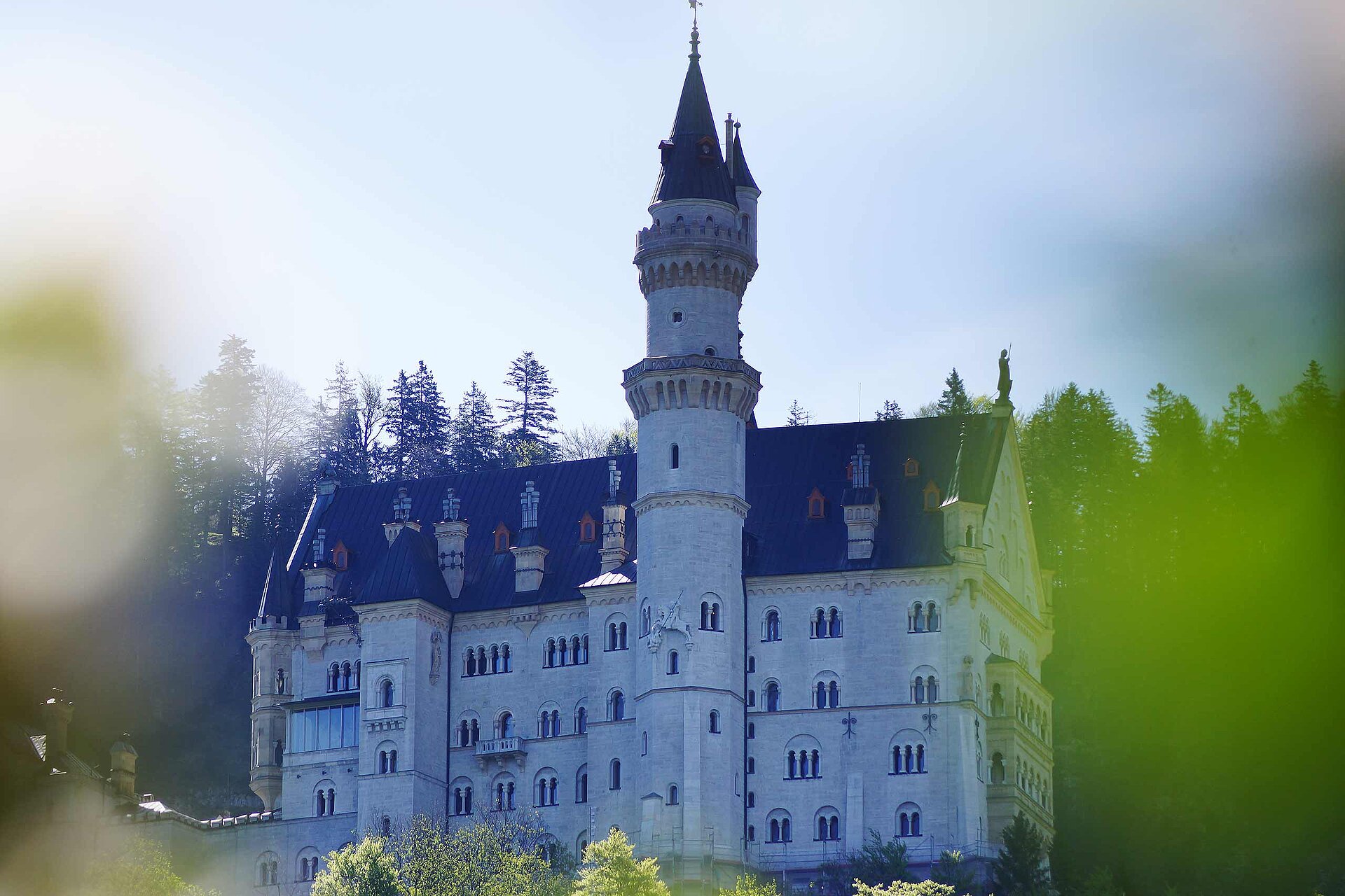
Schloss Neuschwanstein
Besucherinformationen, Öffnungszeiten, Tickets, Fotos
Schloss Hohenschwangau
Besucherinformationen, Öffnungszeiten, Tickets und Fotos
König Ludwig II. von Bayern
Informationen über den "Märchenkönig": Sein Leben und seine Bauwerke
Museum der bayerischen Könige
Im Museum der bayerischen Könige erfahren Sie alles über die Dynastie der Wittelsbacher
Königliche Kristall-Therme
Wellness, Saunen, Aussenbecken, Solebäder und Massagen. Lassen Sie es sich gut gehen!
Tegelbergbahn mit königlicher Aussicht
Wahrhaft königliche Aussichten und idealer Ausganspunkt für Ihre Erkundungen
Kulturelles und Brauchtum
Tradition, Kultur und Brauchtum werden in Schwangau groß geschrieben!
Aktivitäten
Wandern und Klettern
Im Wanderparadies Schwangau gibt es auf dem Berg und im Tal viele Wege zu entdecken!
Seen und Badespaß
Hinein ins kühle Nass, 4 Seen erwarten Sie! Auch im Winter lässt es sich in der königlichen Kristalltherme gut baden!
Wellness und Kuren
Als heilklimatischer Kurort bietet Schwangau viele Möglichkeiten zu entspannen und zu genesen.
Radfahren und mehr
Für Mountainbiker und Genussradler bietet Schwangau die besten Möglichkeiten!
Schwangau im Winter
Entdecken Sie die Wintersportarena und unser riesiges Loipennetz.
Ausflüge und Sehenswertes
Neben den Königsschlössern gibt es Sehenswürdigkeiten und Ausflüge zuhauf!
Gleitschirm- und Drachenfliegen
Willkommen im Fliegermekka am Tegelberg in Schwangau!
Spaß mit Kindern, bei jedem Wetter!
Wir können zwar keine Schönwetter-Garantie leisten, dafür aber Anti-Langeweile-Garantie mit unserem Familien- und Kinderprogramm!
Service
Kontakt Tourist Information
Wir sind Ihnen gerne behilflich! Hier können Sie mit uns Kontakt aufnehmen.
Prospekte und Infomaterial
Hier bekommen Sie weitere Informationen für Ihren Urlaub
Schwangauer Newsletter abonnieren
Mit unserem E-Mail Newsletter bleiben Sie automatisch über Schwangau auf dem Laufenden
Lage, Anfahrt und interaktive Karten
Wo ist ein Geldautomat? Gibt es eine Apotheke? Hier finden Sie unsere Karten und Pläne.
Gratis Bus, Bahn & WLAN
Gäste mit SchwangauCard oder KönigsCard nutzen Bus, Bahn und WLAN gratis
Einkaufen in Schwangau
Alles, was man braucht und noch vieles mehr gibt es rund um Schwangau zu kaufen.
Extranet für Partner und Leistungsträger
Partnerbetriebe, Gemeinderäte und Mitarbeiter der Gemeinde Schwangau finden hier zusätzliche Informationen.
Aktuelle Öffnungszeiten
Öffnungszeiten der Tourist Information
Veranstaltungen
Veranstaltungskalender
Alle Veranstaltungen und Events in Schwangau, am Bergsportzentrum und an der Wintersportarena
Erlebnisse buchen
Hier können Sie Erlebnisse in Schwangau direkt buchen
Tourist Information Schwangau
www.schwangau.de
Aktivitäten
Schwangau im Winter
Ski, Langlauf, Winterwandern
Zurück zur Übersicht
Premium
Premium Inhalt
Strecke
Dauer
Aufstieg
Abstieg
Höchster Punkt
Tiefster Punkt
Diese Tour kann nicht freigeschaltet werden.
Bereits freigeschaltet? Anmelden
Premium
Premium Inhalt
Premium-Touren werden von professionellen Autoren oder Fachverlagen herausgegeben.
Like uns bei facebook
Interaktive Karten
Finde uns bei Instagram